
By Edison Miguel
Wildfires have become an increasingly urgent issue in Los Angeles, devastating communities, ecosystems, and infrastructure. As an environmental advocate with a background in geospatial and environmental science, I’ve always been drawn to understanding how natural disasters impact our world. In this article, I analyze the recent wildfires in Los Angeles through detailed burn severity maps, which help us visualize the extent of the damage and guide recovery efforts. These maps are not just tools for scientists—they are a way for us to see the real-world consequences of climate change and take meaningful action.
This article will explore the causes and impacts of the Palisades and Eaton fires, using burn severity maps to illustrate the destruction. I’ll also discuss the broader environmental crisis, the role of climate change, and how young people can contribute to solutions. Sadly, the wildfires also hit close to home: our network’s Naturefriends House in California was damaged, serving as a stark reminder of what’s at stake. (See: Naturefriends House on Instagram)
A Community in Ashes
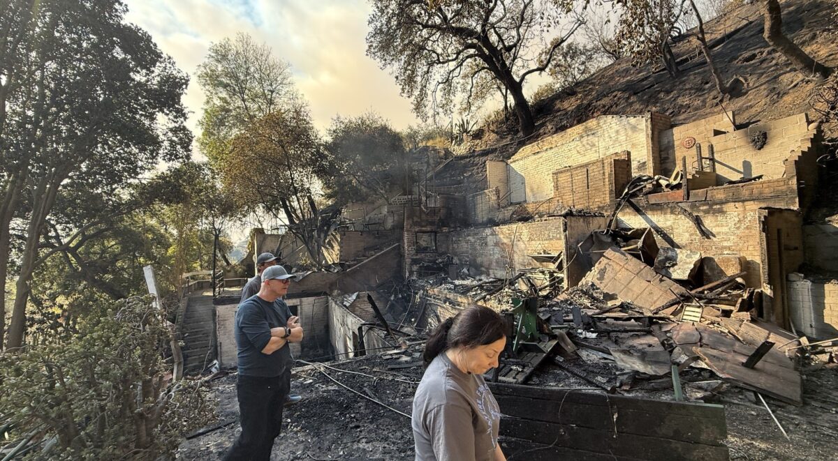
“My community is gone. It’s just a curse that my house is there.”
These were the words of Jeff Lipsy, a longtime resident of Pacific Palisades, as he stood before the charred remains of his home. In an interview with New York Magazine, Lipsy described the devastation left by the wildfires, recalling how familiar streets were reduced to smoldering ruins and how his once-thriving neighborhood had been erased overnight. His story is a haunting reminder of the relentless destruction these fires bring—not just to landscapes, but to the lives of those who call these places home.
Understanding the Crisis
Los Angeles is no stranger to wildfires, but recent events have taken a dramatic turn. Factors such as rising temperatures, prolonged droughts, and human activities have combined to create a wildfire season more destructive than ever. As flames engulf neighborhoods like Pacific Palisades and Altadena, experts work tirelessly—using satellites, aerial surveys, and firsthand reports—to track the fires and assess their impact.
Recent research by World Weather Attribution reveals that climate change has significantly increased the likelihood of wildfire disasters in highly exposed areas like Los Angeles. Their analysis shows that higher average temperatures, reduced precipitation, and intensified drought conditions have dried out vegetation to critical levels, making it far more susceptible to ignition. Extreme wind events, such as the notorious Santa Ana winds, then fan the flames, causing fires to spread rapidly and uncontrollably.
What Happened in Palisades and Eaton?
In the neighborhoods of Palisades and Eaton, wildfires broke out, leaving a trail of destruction in their wake. Scientists and firefighters work together to track these events using a mix of satellites, aerial surveys, and on-the-ground reports. By gathering information on the date, location, and size of the fires, they can better understand how and why these events spread.
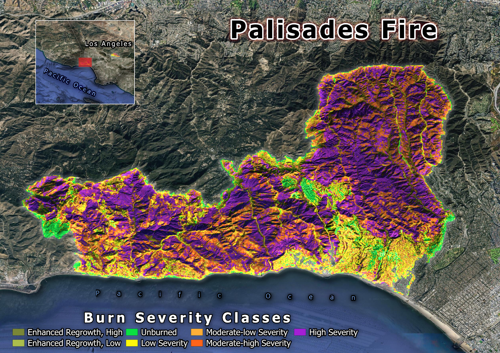
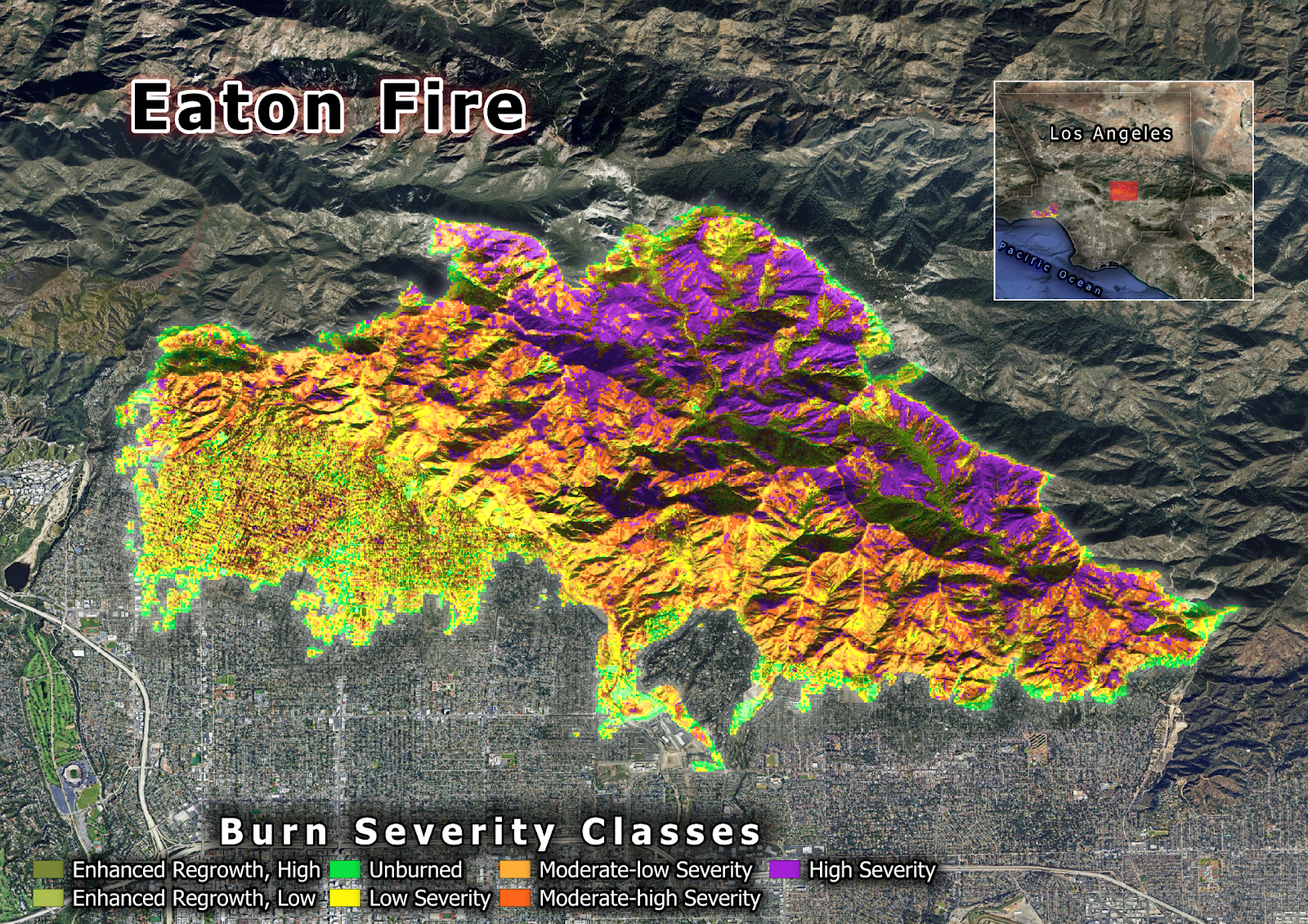
Wildfires don’t just leave behind burned landscapes—they reshape entire ecosystems, displace wildlife, and destroy infrastructure. To understand the full extent of their impact, scientists use burn severity mapping, a method that categorizes fire-affected areas based on how much vegetation and soil have been damaged. This information is crucial for disaster response, helping authorities assess recovery needs, allocate resources, and plan reforestation efforts.
Using this approach, I created two burn severity maps to visualize the destruction caused by the Palisades and Eaton fires. These maps use color-coded classifications from the U.S. Geological Survey (USGS) to differentiate between areas that experienced low, moderate, and high burn severity. By comparing satellite images taken before (January 2, 2025) and after (February 1, 2025) the fires, we can see the true scale of the damage—both in terms of land area affected and the number of structures lost.
This image shows the burn severity map of the Palisades fire which burned 94.89 km2 and damaged or destroyed more than 6,800 structures.
This image shows the burn severity map of the Eaton fire which burned 56.74 km2 and damaged or destroyed more than 10,491 structures.
The Environmental Impact
Wildfires have a profound effect on our world, and their consequences extend far beyond the immediate destruction. Here are some key ways they impact the environment:
- Ecosystems and Wildlife: Forests and parks are like busy communities where every plant and animal plays a role. When a wildfire hits, many animals lose their homes, and plants that once helped clean our air are gone.
- Air Quality and Health: The thick smoke from wildfires can make it hard to breathe. For people, especially those with asthma or allergies, this means extra challenges during and after the fires.
- Long-Term Damage: Trees and plants help keep our planet cool by absorbing carbon dioxide. When they burn, more carbon stays in the air, which speeds up climate change. Plus, without trees to hold the soil together, erosion can become a serious problem, making it difficult for nature to recover.
How Can We Stay Informed and Take Action?
Even though wildfires can seem overwhelming, there are many ways we—especially as young people—can make a difference:
- Stay Informed and Learn About Climate Resilience:
- Learn about climate resilience by following trusted sources like the World Weather Attribution, National Oceanic and Atmospheric Administration, and the Intergovernmental Panel on Climate Change reports to keep up with scientific information on climate resilience.
- Understand how communities prepare for natural disasters. Ask your teachers, join local clubs, or even explore online resources to learn more about building a safer future.
- Support Local Initiatives:
Get involved in local projects, like tree-planting initiatives or fire prevention programs. Volunteering your time or simply spreading the word can help rebuild and protect your community. - Be Fire-Safe Outdoors:
Whether you’re camping or hiking, always check for fire alerts and follow safety guidelines. Simple precautions can prevent accidental fires.
These steps not only help restore nature but also strengthen our communities, making them safer and more resilient to future wildfires.
The Future and Our Role
The recent wildfires in Palisades and Eaton are more than just isolated incidents; they are a clear sign of a larger, worrying trend. They remind us that every part of our environment is connected and that the choices we make today can shape our future. As young people, you have the energy, creativity, and passion to drive change.
Whether it’s spreading awareness, volunteering for local initiatives, or simply being informed, every action counts. Together, we can work towards a future where our communities and our environment are safe from the devastating effects of wildfires.
Sources:
- Story about Jeff Lipsy: https://nymag.com/intelligencer/article/la-fires-wildfires-lost-homes-rebuild.html?utm_campaign=feed-part&utm_medium=social_acct&utm_source=rss
- Fire perimeter shapefile taken from the National Interagency Fire Center FIRIS: https://hub.arcgis.com/maps/ad51845ea5fb4eb483bc2a7c38b2370c/about
- Climate change increases the likelihood of wildfire disaster in Los Angeles: https://www.worldweatherattribution.org/climate-change-increased-the-likelihood-of-wildfire-disaster-in-highly-exposed-los-angeles-area/
- Data of the burned area and burned/damaged structures: https://www.fire.ca.gov/incidents/2025/1/7/palisades-fire
- Sentinel 2 satellite imagery from the Copernicus browser: https://browser.dataspace.copernicus.eu/
- Burn severity mapping script by UN-Spider: https://www.un-spider.org/advisory-support/recommended-practices/recommended-practice-burn-severity-mapping